How do you give a star an address?
Scrollable formula. Use Left and Right arrow keys to reveal hidden content.
Scrollable table. Use Left and Right arrow keys to reveal additional columns.
Scrollable figure. Use Left and Right arrow keys to inspect hidden content.
https://blackhole.org/universe/sky/sky-coordinates/
“Look over there” works only if someone can follow your finger. Astronomers need directions that another observer can measure and check. Sky coordinates provide those directions. One useful grid starts with your horizon; another starts with Earth’s equator projected onto the sky. Neither tells us how far away a star is.
Predict first. If you keep watching a star for two hours, should its address change? The answer depends on which coordinate system you use.
Altitude and azimuth: your local sky
Section titled “Altitude and azimuth: your local sky”Your horizon is the boundary between sky and ground in an ideal, unobstructed view. Altitude measures the angle above that horizon: zero degrees at the horizon and 90 degrees at the zenith, directly overhead. Negative altitude means below the ideal horizon.
Azimuth measures direction around the horizon. Here we measure it from true north toward east: north is 0°, east 90°, south 180°, and west 270°. A direction described as “azimuth 90°, altitude 30°” is due east and one-third of the way from the horizon to overhead. True north refers to Earth’s rotation axis; a magnetic compass may need a local correction. USNO n.d., “Computing Altitude and Azimuth,” coordinate definitions
Inspect the altitude angle on the left of the figure. The right panel introduces a different grid; the example points are illustrative, not a prediction for a particular observer or date.
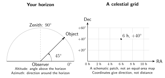
Two ways to describe a sky direction. The left schematic is a vertical slice through the observer and an object at altitude 45°. The right is a schematic patch of an equatorial grid with an illustrative point at right ascension 6 hours and declination +40°. The panels do not show a coordinate transformation for a real star.
Altitude and azimuth depend on your location and the time. Earth’s rotation carries your horizon around, making many stars appear to rise, cross the sky, and set. Someone far away on Earth has a different horizon and can see the same star in a different direction—or not above the horizon at all.
Right ascension and declination: a shared map
Section titled “Right ascension and declination: a shared map”Imagine surrounding Earth with a huge imaginary sphere. Project Earth’s equator onto it to make the celestial equator, and extend the rotation axis to identify celestial north and south. The sphere organizes directions; it does not claim that stars sit on a shell at one distance.
Declination, abbreviated Dec, is the angular position north or south of the celestial equator. Positive values are north, negative values south. The celestial equator is 0°, and the poles are +90° and −90°.
Right ascension, abbreviated RA, measures around the equatorial grid from its reference direction. It is commonly written in hours, minutes, and seconds, with 24 hours completing the circle. Those “hours” label an angle, not the time at which a star rises. A catalog might give RA 6 h and Dec +40°; this is enough to mark a direction on the grid but not to locate an object in three-dimensional space. USNO n.d., “Frequently Asked Questions,” § What is a celestial reference frame?
For precision, astronomers state the reference frame and the date associated with a catalog position. Stars really move, Earth’s axis slowly changes direction, and observation introduces further corrections. A catalog address is much steadier over one evening than altitude/azimuth, but it is not an eternally fixed label. USNO n.d., “International Celestial Reference System,” reference-system discussion
| Question | Horizon coordinates | Equatorial coordinates |
|---|---|---|
| What are the two labels? | Altitude and azimuth | Right ascension and declination |
| What anchors the grid? | The observer’s horizon and compass directions | A stated celestial reference system |
| What is especially useful? | Pointing in your local sky at a stated time | Sharing and cataloging sky directions |
| Does it give distance? | No | No |
Turning a catalog direction into a local direction
Section titled “Turning a catalog direction into a local direction”To turn RA and Dec into altitude and azimuth, you also need the observer’s position and the time. Earth’s orientation connects the two grids. A planetarium program performs this calculation, but its result is only useful when those inputs and conventions are right.
For example, a printed chart for one latitude and evening cannot simply be read as a forecast for the opposite hemisphere six months later. Trees, buildings, weather, and daylight introduce further limits: a calculated object above the horizon is not guaranteed to be visible.
Show the math: hours are angles
One full turn is both 360° and 24 h of right ascension, so
A difference of 2 h is therefore 30° around the equatorial coordinate grid. This is not generally the shortest angular separation between two stars. At high declination, the circles of constant declination are smaller, just as circles of latitude shrink toward Earth’s poles.
Could two stars share an address?
Section titled “Could two stars share an address?”Suppose two stars appear in the same direction, but one is ten times farther away. Could they have the same RA and Dec?
Answer
Yes. Angular coordinates describe a line of sight. Objects at different distances can lie along almost the same line, just as a nearby streetlamp can appear beside a distant mountain. Measuring distance needs additional evidence, such as parallax. A sky chart is not a complete three-dimensional map.
For classrooms and clubs
Preparation: compass directions and angles. Objective: choose a coordinate system for a task. In 15 minutes, label an indoor dome sketch with north, east, horizon, and zenith, then place an object at east/30°. It should lie one-third of the angular way from the eastern horizon to the zenith; 30° is an angle, not a distance to the star. Verbal directions give an equivalent activity.
For a longer extension, compare two horizon sketches at different times with the same catalog grid. Earth’s rotation changes the observer’s orientation, so the local direction changes even when the star’s catalog coordinates are essentially unchanged over the exercise. The common misconception is that right ascension 6 hours means “rises at 6 o’clock”; it denotes an angular coordinate and needs location and time to become a horizon direction. Use supplied diagrams indoors rather than asking students to share home locations or travel to an observing site.
Continue with time and calendars, or see how tiny changes in a star’s direction can reveal its distance through parallax.
References
Section titled “References”- U.S. Naval Observatory, Astronomical Applications Department. “Computing Altitude and Azimuth from Greenwich Apparent Sidereal Time.” n.d. Definitions and equations. Accessed September 27, 2026.
- U.S. Naval Observatory, Astronomical Applications Department. “International Celestial Reference System.” n.d. Reference systems and frames. Accessed September 27, 2026.
- U.S. Naval Observatory, Celestial Reference Frame Department. “Frequently Asked Questions.” n.d. Celestial reference-frame explanation. Accessed September 27, 2026.